Size: 112.7 square miles, 72,162 acres
Identified: 07/2010
Visiting the IBA: Take Highway 87 North from Payson, AZ. North of Pine, AZ, Forest Road 300 “Rim Road” heads east from the 87 and travels through the IBA. This is a relatively primitive area offering stunning views and many opportunities to pull off and explore the habitat.
Ownership: Coconino and Apache Sitgreaves National Forests
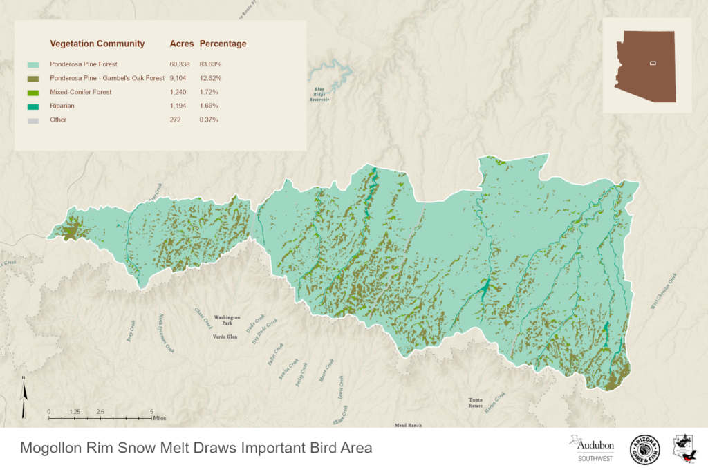
Site Description: This IBA encompasses drainages located within 8 km of the edge of the Mogollon Rim, an abrupt cliff that represents the southern extension of the Colorado Plateau. This edge of the rim has a narrow band of moist vegetation (especially maples) associated with greater precipitation formed by the upward deflection of air at the rim face.  The habitat of this IBA includes Ponderosa pine, white fir, Douglas fir, southwestern white pine, quaking aspen, and Gambel oak. Young plants of these canopy trees, plus canyon maple and New Mexico locust dominate the understory woody species.
Birds: This A long-term study (since 1986) of a high elevation riparian ecosystem and bird community demonstrates complex effects of climate impacts and has shown this area to be significant habitat for many woodpecker species.
Year-round: Mountain Chickadee, Red-breasted Nuthatch, White-breasted Nuthatch, Pygmy Nuthatch, Brown Creeper
 Breeding: Northern Flicker, Red-naped Sapsucker, Williamson’s Sapsucker, Hairy Woodpecker, Downy Woodpecker, Acorn Woodpecker, American Three-toed Woodpecker, Olive-sided Flycatcher, MacGillivray’s Warbler, Red-faced Warbler, Virginia’s Warbler, Grace’s Warbler, Western Bluebirds, Band-tailed Pigeon, Broad-tailed Hummingbird, Warbling Vireo, Steller’s Jay, Violet-green Swallow, Ruby-crowned Kinglet, Hermit Thrush, Green-tailed Towhee, Dark-eyed Junco, Western Tanager, and Red Crossbill
Migration: Townsend’s Warbler, Hermit Warbler and Wilson’s Warbler
eBird focus species: Williamson’s Sapsucker, American Three-toed Woodpecker, Olive-sided Flycatcher, and MacGillivray’s Warbler.
Conservation Issues: Long-term declines in winter snowfall have been associated with a decline in deciduous trees because it influences over-winter presence of elk that over-browse the habitat in winters with lower snowfall Large herbivores have been found to impact a variety of systems, and aspen in the western North America seems particularly susceptible.
Maps of this Important Bird Area:

Mogollon Rim Snowmelts Draw IBA GIS Map – zoomed out
Mogollon Rim Snow Melt Draws Important Bird Area | Arizona Wildlife Conservation Strategy
Complete eBird.org Checklist of birds Reported for Mogollon Rim Snowmelt Draws IBA
For an interactive map and habitat and land ownership analysis of this IBA visit the National Audubon IBA Map and select “Arizona” and then the name of this Important Bird Area. To access analysis graphs, click on the map boundary of the IBA.
Location: UTM 12- 03808427 N 488566 E NAD 27
County: Coconino
Site Status: Identified 07/2010
Ownership: Apache-Sitgreaves National Forest
Area: 112.7 square miles, 72,162 acres
Criteria: D1 – Site Important to Special Status Avian Species (Red-faced Warbler, Grace’s Warbler, MacGillivray’s Warbler, Virginia’s Warbler, Olive-sided Flycatcher
D5 – Sites supporting substantive programs in avian research or avian-specific educational opportunities
D5A – Sites supporting long-term research and /or monitoring with publication of research, e.g. Western Birds, Journal of Field Ornithology, Southwestern Naturalist, Condor, etc.
Site Description: The habitat of this IBA includes Ponderosa pine (Pinus ponderosa), white fir (Abies con- color), Douglas fir (Pseudotsuga menziesii), southwest- ern white pine (Pinus strobiformis), quaking aspen (Populus tremuloides), and Gambel oak (Quercus gambelii). Young plants of these canopy trees, plus canyon maple (Acer grandidentatum) and New Mexico locust (Robinia neomexicana) dominate the understory woody species. The drainage areas contrast with surrounding forest, which is primarily ponderosa pine with Gambel oak in the sub-canopy and little understory vegetation.
| Vegetation Description | Hectares |
| DOUGLAS FIR – WHITE FIR COMMUNITIES | 13375.97 |
| MONTANE (MOUNTAIN MEADOW) GRASSLAND | 3.000016 |
| PINE COMMUNITIES | 579124.2 |
Snowmelt Canyons flowing north from the Mogollon Rim on the Coconino and Apache Sitgreaves National Forests. East boundary is Chevelon Butte Road (FS Route 99); South boundary is the Rim Road (FS 300); West boundary is FR 147; North boundary is T12 1/2 North (Latitude 34 degrees 27’ 49” N).
Coconino National Forest Snowmelt Canyons and side draws: Kehl, Miller, Hi Fuller, Crackerbox, General Springs, Box, Fred Haught, Bear, Maverick, Bar.

Brown Creeper by Kelly Colgan Azarbershop, Dane, Yeager, Leonard.Apache-Sitgreaves Forest Snowmelt Canyons and side draws: Leonard, Gentry, Turkey Creek, Beaver, Bear, Willow Creek
Stanley Zimny
The drainages are located within 8 km of the edge of the Mogollon Rim, an abrupt cliff that represents the southern extension of the Colorado Plateau. The edge of the rim has a narrow band of moist vegetation (e.g., maple) associated with greater precipitation formed by the upward deflection of air at the rim face. No history of fire in over 50 years in these drainages. Twenty-two snowmelt drainages located on the Mogollon Rim in central Arizona at 2600 m elevation are part of a long term ecological study. Project Title: Effect of Climate Change on Population Trajectories and Trophic Interactions in a High Elevation Riparian Ecosystem Principal Investigator: Thomas E. Martin, USGS Montana Cooperative Wildlife Research Unit.
Directions to IBA: If you are coming in from Flagstaff, take the Lake Mary road off I-40 and head east to Clint’s Well (a small “town” that consists of a gas station/café and a post office). Driving from Phoenix, head north on Highway 87 to Clint’s Well. Driving from Winslow head south on Highway 87 to Road 95. Proceed ten miles north of Clint’s Well on Highway 87 to the U.S. Forest Service’s Blue Ridge Ranger Station; about 300 meters north of the Ranger Station is gravel road number 95; turn right on this road (if you’re approaching from Winslow, turn left on this road). Drive several miles on this road, to the bottom of a very deep canyon. After crossing the bridge at the canyon bottom, go left onto Road 96. Road 96 ends in a ‘T’ intersection; turn right onto Road 137 (toward Buck Springs). Stay on Road 137 until you get to Hospital Ridge road.
Ornithological Summary: This IBA is a significant breeding habitat in Arizona for species of conservation concern: Olive-sided Flycatcher, MacGillivray’s Warbler, Red-faced Warbler, Virginia’s Warbler & Grace’s Warbler.
Thirty-two species of breeding birds have been studied for over 20 years by Dr. Tom Martin and associates. Individuals of all bird species are counted on the same nine plots from mid-May to mid-June each year from 1985 through 2005. Bird abundance is standardized to numbers of pairs per the standard 625 m length across all plots.

American Three-toed Woodpecker by Ron Knight
A long-term study (since 1986) of a high elevation riparian ecosystem and bird community in north-central Arizona demonstrates complex effects of climate impacts on this ecosystem. Birds in this system also breed earlier in warmer years: However, earlier breeding did not affect demography of birds. Instead, other ecosystem responses to climate variation affected bird populations. Long-term declines in winter snowfall have been associated with a decline in deciduous trees because it influences over-winter presence of elk that over-browse the habitat in winters with lower snowfall. Bird species, such as MacGillivary’s Warbler, Red-faced Warbler, Orange-crowned Warbler, Hermit Thrush, and Green-tailed Towhee have declined in association with the loss of plants that represent their preferred habitat. In general, Virginia’s Warblers prefer xeric microhabitats dominated by locust high on slopes. Gray-headed Juncos prefer open grassy sites with an abundance of locust, indicating a tendency toward xeric sites. Red-faced Warblers prefer more mesic sites dominated by small firs and maple relatively low on the slope, and Orange-crowned Warblers prefer mesic microhabitats dominated by maple low on the slope (Martin 1998).
Cavity-nesting bird breeding data from 22 snowmelt drainages located on the Mogollon Rim in central Arizona at 2600 m elevation. Pingjun Li and Thomas E. Martin. Nest-site selection and nesting success of cavity-nesting birds in high elevation forest drainages. The Auk 108: 405-418. April 1991.
| Species | Scientific Name | building | incubating | feeding | Total |
| Northern Flicker | Colaptes auratus | 6 (4/2/0) | 9 (9/0/0) | 22 (21/1/0) | 37 (34/3/0) |
| Red-naped Sapsucker | Sphyrapicus varius | 6 (5/1/0) | 7 (6/1/0) | 7 (7/0/0) | 20 (18/2/0) |
| Williamson’s Sapsucker | Sphyrapicus thryoides | 6 (6/0/0) | 16 (14/0/2) | 14 (14/0/0) | 36 (34/0/2) |
| Hairy Woodpecker | Picoides villosus | 1 (1/0/0) | 2 (1/0/1) | 5 (5/0/0) | 8 (7/0/1) |
| Downy Woodpecker | Picoides pubescens | 1 (1/0/0) | 1 (1/0/0) | 1 (1/0/0) | 3 (3/0/0) |
| Acorn Woodpecker | Melanerpes formicivorus | 3 (2/0/1) | 6 (6/0/0) | 4 (3/1/0) | 13 (11/1/1) |
| Cordilleran Flycatcher | Empidonax difficilisa | 18 (5/2/11) | 14 (4/1/9) | 3 (3/0/0) | 35 (12/3/20) |
| Mountain Chickadee | Parus gambeli | 7 (2/0/5) 7 ( | 4/1/2) | 15 (15/0/0) | 29 (21/1/7) |
| White-breasted Nuthatch | Sitta carolinensis | 0 (0/0/0) | 4 (1/1/2) | 6 (5/0/1) | 10 (6/1/3) |
| Red-breasted Nuthatch | Sitta canadensis | 6 (3/1/2) | 6 (3/2/1) | 2 (2/0/0) | 14 (8/3/3) |
| Pygmy Nuthatch | Sitta pygmaea | 5 (4/0/1) | 4 (3/0/1) | 9 (9/0/0) | 18 (16/0/2) |
| Brown Creeper | Certhia americana | 2 (1/0/1) | 0 (0/0/0) | 3 (3/0/0) | 5 (4/0/1) |
| House Wren | Troglodytes aedon | 53(35/3/15) | 26 (18/2/6) | 41 (41/0/0) | 120(94/5/21) |
| Western Bluebird | Sialia mexicana | 1(0/0/1) | 4 (3/0/1) | 3(3/0/0) | 8(6/0/2 |
356 nests were found, including 140 in 1987, 119 in 1988, and 97 in 1989
Conservation Issues: Large herbivores have been found to impact a variety of systems, and aspen in the western North America seems particularly susceptible. Other important deciduous plants also appear to get hit hard by large herbivores. Maple, locust, aspen and other deciduous plants have declined dramatically in this high elevation (7800′ elevation) snowmelt drainages riparian system. Aspen has had zero recruitment for at least 50 years in these drainages. The decline in these plants and lack of recruitment may also be influenced by climate change, which is also being studied. To separate browsing and climate effects on this ecosystem, a large-scale experiment was initiated in the summer of 2004. Entire drainages of 9 ha (600 m long by 150 m wide) were fenced to exclude elk and deer. Study plots are snowmelt drainages that drain from ridges into canyons.