 Size: 26.31 square miles, 16843 acres
Identified: 01/2004. Recognized: 01/2010
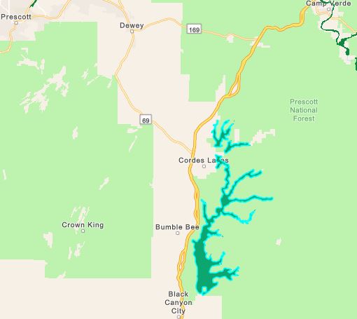
VISITING THE IBA: The Agua Fria National Monument is located 40 miles north of Phoenix, AZ. It is easily accessed by traveling on Interstate 17 to the Badger Springs Exit (Exit #256), Bloody Basin Road Exit (Exit #259) or Cordes Lakes and Dugas exits. Badger Springs Wash – Arizona Birding Trail
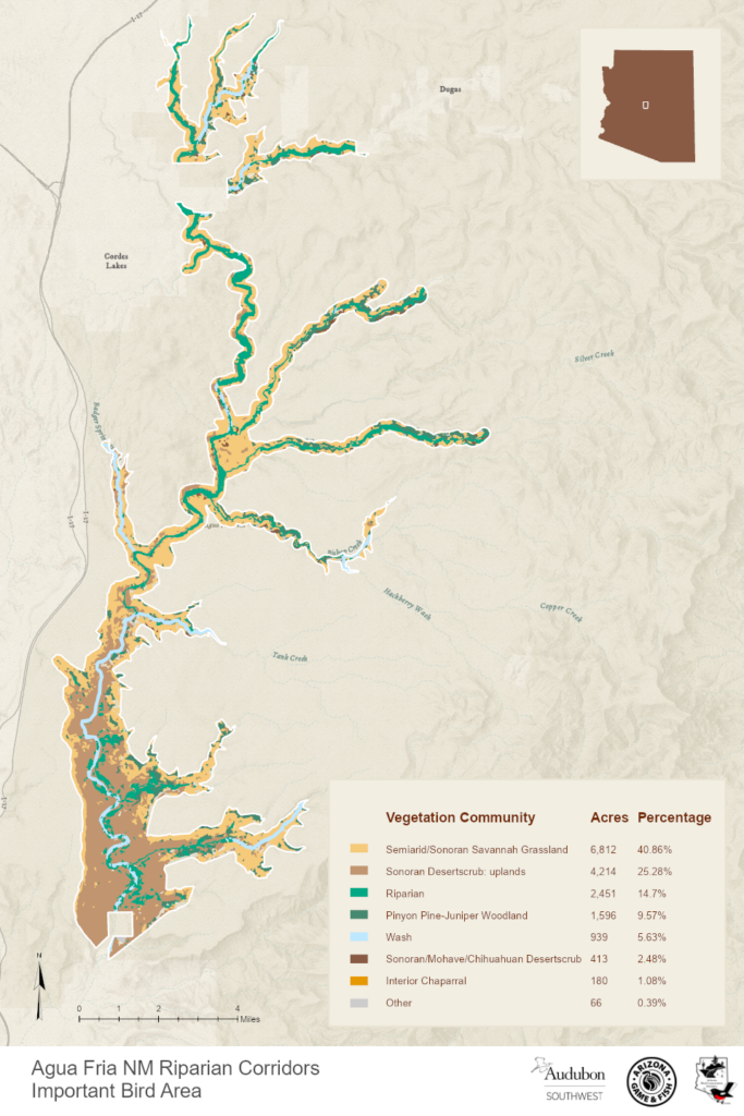
SITE DESCRIPTION: Agua Fria National Monument consists of semi-desert grassland mesas with pockets of chaparral, mesquite and desert riparian communities. A number of wells and watering tanks create local micro-habitats. The IBA is the deeply cut canyons of the Agua Fria River and tributaries that contain mature riparian forests of Fremont cottonwood, Goodding and other willows, Arizona ash and Arizona sycamore. At the lower end of the main canyon above Black Canyon City this habitat is dominated by cottonwoods and merges into sycamore dominated riparian forests at the highest altitudes.

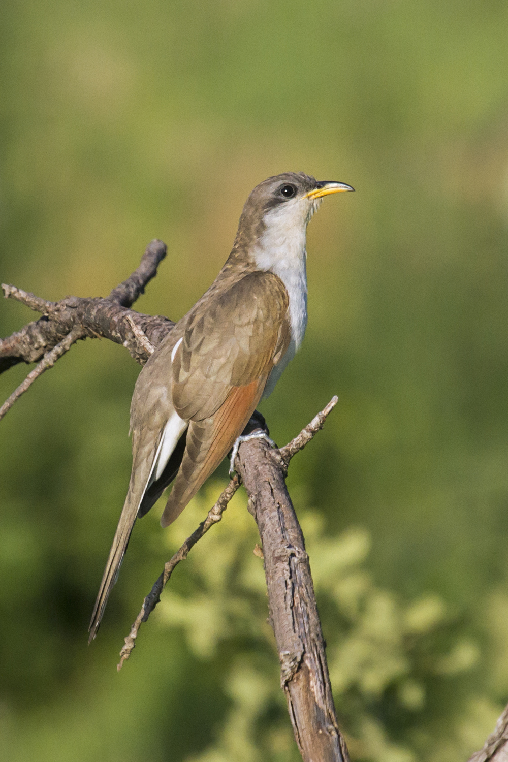
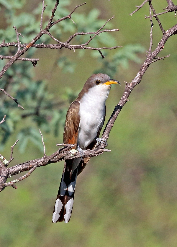
Yellow-billed Cuckoo by Larry Smith
BIRDS: Species of special conservation status and interest that use the habitats within this IBA include:
Breeding: Great Blue Heron, Common Black-Hawk, Zone-tailed Hawk, Peregrine Falcon, Cooper’s Hawk, Golden Eagle, Yellow-billed Cuckoo, Black-throated Hummingbird, Bell’s Vireo, Juniper Titmouse, Lucy’s Warbler, Yellow Warbler, Abert’s Towhee, Black-throated Sparrow, Song Sparrow, Summer Tanager, Blue Grosbeak, Lazuli Bunting, Bullock’s Oriole, and Hooded Oriole.
Migration: Swainson’s Hawk, Bald Eagle, Red-naped Sapsucker, Southwestern Willow Flycatcher, Gray Flycatcher, Olive-sided Flycatcher, Cordilleran Flycatcher, Crissal Thrasher, Gray Vireo, Virginia’s Warbler, Black-throated Gray Warbler, MacGillivray’s Warbler, Townsend’s Warbler, Lark Bunting, and Brewer’s Sparrow.
CONSERVATION CONCERNS: Grassland and riparian habitat health requires management of grazing, off highway vehicle travel and fire. Loss of the grasslands impacts the small Pronghorn Antelope population and the grassland bird assemblage (sparrows, meadowlarks, and Gambel’s quail). Native fishes, including longfin dace, the Gila mountain sucker, the Gila chub, and the speckled dace, exist in the Agua Fria River and its tributaries. Immediate concerns are: spread of invasive plants and animals such as tamarisk and crayfish, as well as illegal off-road vehicle use. Upstream groundwater extraction is a potential serious threat as development proceeds along the I-17 corridor. Strategies: management of upstream groundwater extraction and development, off-highway vehicle management, seasonal exclusion of livestock from the riparian areas, and fire management through prescription fires.
CONSERVATION STEWARDS: Sonoran Audubon Society and Friends of Agua Fria National Monument
Mini Conservation Plan for Agua Fria NM Riparian Corridors IBA
Arizona Game and Fish Department Conservation Opportunity Area
Complete eBird.org Checklist of birds Reported for Agua Fria NM Riparian Corridors IBA
For an interactive map and habitat and land ownership analysis of this IBA visit the National Audubon IBA Map and select “Arizona” and then select this IBA
Location: 34.3152°N: 112.0641°W
County: Yavapai
Site Status: Identified 01/2004, Recognized January 9, 2010
Ownership: U.S. Bureau of Land Management
Size: 26.31 square miles, 16,843 acres
Criteria: State: Species of Conservation Concern
State: Species in rare/unique habitat: Riparian
State: Outstanding landbird stopover
Site Description: The Agua Fria National Monument, east of I-17 from Black Canyon City to above Cordes Junction, is generally a series of plateaus and mesas deeply cut by the Agua Fria River and its major tributaries. The principal bird attractor is the 26.5 miles of riparian corridor along the Agua Fria and within the tributary canyons. Much of this is mature, native riparian woodland with cottonwoods, willows, sycamores and mesquite. Sonoran Audubon Society and Friends of the Agua Fria National Monument are the stewards for this IBA. Sonoran Audubon volunteers are conducting bird surveys in all seasons and are members of the Agua Fria Watershed Partnership and Friends of the Agua Fria National Monument. Information about the Sonoran Audubon Society IBA bird monitoring program can be found in their e-newsletter at www.sonoranaudubon.org.
Target Bird Species: The extensive riparian woodland along the Agua Fria River and its tributaries provides both breeding and wintering habitat for a number of bird species and constitutes a recently discovered migration route paralleling the one along the Verde River. This IBA supports one of the higher densities of nesting Yellow-billed Cuckoos in Arizona. Twenty-eight species with special conservation status occur in the area, including breeding Common Black-Hawk, Peregrine Falcon, Golden Eagle, Yellow-billed Cuckoo, Costa’s Hummingbird, Belted Kingfisher, Gray Flycatcher, Loggerhead Shrike, Bell’s Vireo, Juniper Titmouse, Abert’s Towhee, Lucy’s Warbler, and Yellow Warbler.
| Species or group | Season | Maximum Observed | Year |
| Yellow-billed Cuckoo | Late Summer | 20 Individuals | 2002 |
| Lucy’s Warbler | Breeding | 84 Individuals | 2002 |
| Belted Kingfisher | Breeding | 11 Individuals | 2002 |
| Bell’s Vireo | Breeding | 53 Individuals | 2002 |
| Common Black-Hawk | Breeding | 4 Individuals | 2002 |
| Gray Flycatcher | Breeding | 17 Individuals | 2002 |